The Complete Guide to Tadiandamol Trek
Tadiandamol Trek is a popular adventure that attracts trekkers from all over Southern India, particularly those visiting the scenic hill town of Madikeri in Coorg. This trek, which leads to the highest peak in the Kodagu district and the third highest peak in Karnataka, offers trekkers an exciting challenge through the Western Ghats’ natural beauty.
Overview
- Location: Western Ghats, Coorg (Kodagu), Karnataka
- Elevation: 5,735 feet (1,748 meters)
- Trekking Region: Brahmagiri Wildlife Sanctuary, Bhagamandala Range Forest
- Difficulty Level: Moderate to Challenging
- Duration: Typically 1-2 days (Depending on pace)
What to Watch Out For:
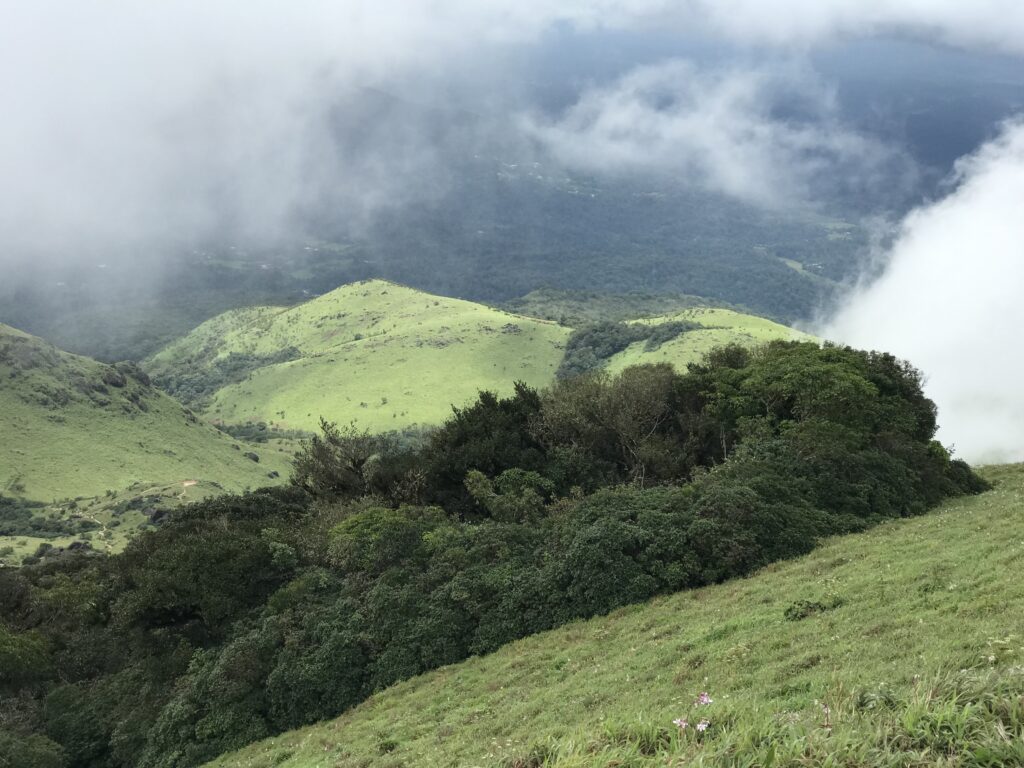
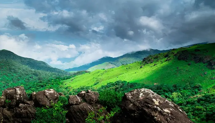
- Stunning Views of Rolling Green Hills: As you climb, the panoramic views from the summit are a major highlight. The sight of endless green hills and the serene valleys surrounded by evergreen forests is breathtaking, especially in clear weather. The best time to visit for clear views is just before summer, as the monsoon and post-monsoon seasons bring clouds that obscure the landscape.
- Trekking Through Shola Forests: The trek takes you through the enchanting Shola forests, which are tropical, stunted forests found in valleys amidst rolling grasslands. These forests are rich in flora and fauna. You’ll pass through coffee estates, pepper plantations, Arecanut trees, and Nutmeg trees. A keen observer will be rewarded with sightings of butterflies, millipedes, and possibly even a Calotes Versicolor lizard or a snake. Leeches can also be an issue during the monsoon season.
Trail Information:
The trek follows a well-marked route through diverse terrain, including dense forests, grasslands, and stream crossings. While it is challenging in parts, with steep ascents and rocky patches, it is accessible to fit beginners who prepare adequately.
Best Season to Trek:
- Pre-Summer (March to early May) is ideal for clear skies and great views.
- Monsoon (June to September) is lush but challenging due to mud and leeches.
- Post-Monsoon (October to December) brings vibrant greenery but may still have some cloud cover.
How to Reach:
The nearest town to Tadiandamol is Madikeri, Coorg. From there, it’s about a 30-minute drive to the base of the trek. You can reach Madikeri by:
- Road: Well-connected via buses and taxis from major cities like Bangalore and Mysore.
- Rail: Nearest railway station is in Mysore, around 120 km from Madikeri.
- Air: The nearest airport is in Mangalore (160 km away).
FAQ:
- Is the trek suitable for beginners? Yes, it can be done by fit beginners with some preparation, though it’s a good idea to start early and go with a guide.
- Are there any rest points on the trail? There are no major rest stops along the way, but the route is relatively straightforward and suitable for moderate breaks.
Places to Visit Near Tadiandamol:
- Abbey Falls: A picturesque waterfall near Madikeri.
- Raja’s Seat: A beautiful viewpoint offering a stunning panoramic view of the surrounding valley.
- Madikeri Fort: A historic fort that showcases the culture and architecture of the Coorg region.
- Omkareshwara Temple: A peaceful temple with a mix of Islamic and Hindu architecture.
Tadiandamol Trek is a rewarding adventure, offering both natural beauty and an exciting challenge. Whether you’re a seasoned trekker or a beginner, it’s a must-do for nature lovers and those seeking adventure in the Western Ghats.
Tadiandamol Trek: Getting to the Starting Point
If you’re unsure about the directions or need help navigating, don’t hesitate to ask the locals. They are usually very helpful and will easily guide you on the right path.
Starting the Trek:
From the junction of Aramane and Kakkabe Road, it takes about 15 minutes to reach the point where you need to take a right turn onto Nalknad Palace Road. This road leads you directly to the base of the trek.
Option to Skip the First Section:
If you’re not confident about your fitness level or simply want to skip the initial stretch of the trek, there is an option to do so. You can take a jeep or auto from the bridge to Nalknad Palace. The road to the palace is around 5.5 km long, and skipping it will save you an hour of walking.
- Auto Ride: ₹400
- Jeep Ride: ₹750-800 (shared options are also available, which can reduce the cost).
The Road to Nalknad Palace:
Once you turn onto Nalknad Palace Road, the road is straightforward. Vehicles can easily access the road until you reach the Nalknad Palace. If you have your own vehicle, you can continue directly to the palace, and then follow the next section of the trek from there.
Along the way, you’ll pass several cottages and resorts/homestays (around 5-6). If you plan on staying overnight after your trek, this is a good spot to book accommodation ahead of time.
Flora and Fauna Along the Road:
While walking or riding along this section, keep your eyes open for the lush greenery, pepper and coffee plantations, and various trees like Arecanut, Nutmeg, and Fishtail palms. The area is also home to several species of birds, whose early morning chirping adds to the serene atmosphere.
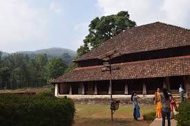
Reaching Nalknad Palace:
The road to the palace is relatively smooth with zigzag paths, and you can expect to reach the palace after about 40 minutes of trekking or driving. However, it’s advised to leave the visit to the Nalknad Palace for after the trek, as it’s best to focus on reaching the peak first. Exploring the palace on your way back will allow you to enjoy it without wasting time during the ascent.
Vehicle Access and New Developments:
Until early 2020, vehicles could only go up to Nalknad Palace, but recently, concrete blocks have been laid further up the road, bringing it closer to the base of Tadiandamol Peak. In the near future, vehicles might be able to drive all the way up to the base, making the trek slightly easier.
In summary, the first section of the trek to Nalknad Palace is quite manageable, and you have the option of skipping it with a short auto or jeep ride. From there, you’ll continue to explore the natural beauty of the region as you trek towards the peak.
Nalknad Palace to Base of Tadiandamol Trek
Trek Distance: 2 km
Trek Duration: 55 minutes
GPS Coordinates of Nalknad Palace: 12°14’07.7″N, 75°38’23.7″E
GPS Coordinates of Base of Tadiandamol: 12°13’54.9″N, 75°37’48.9″E
Trek Overview:
After you leave Nalknad Palace, the trail takes on a gentler incline, transitioning to a mix of mud and gravel roads. This section leads you to the base of Tadiandamol, where the main trekking trail officially begins.
Hidden Waterfall:
Just 5 minutes into the trek from Nalknad Palace, you’ll come across a hidden waterfall. This waterfall is particularly stunning during the monsoon and post-monsoon seasons. Make sure not to miss it! If you want to be sure you visit this spot, it’s marked on the GPX file for the trek. Be sure to download it beforehand.
Trail Description:
- As you head out of the waterfall section, you’ll join the main trail, which takes you through a mix of broken tar road, muddy patches, small gravel paths, and even some concrete sections.
- The environment here is lush and green, with rich vegetation that stretches out for about an hour as you trek.
Refill Water at the Last House:
About half an hour into this section, you’ll pass a small house by the side of a stream. This is a good spot to refill your water bottle before heading further up the trail.
Final Stretch to the Base:
The base of Tadiandamol is just 10 minutes away from this house. As you approach, look for a viewpoint on your right, where you’ll be treated to an expansive view of the entire surrounding region.
This section of the trek is relatively straightforward, and the gentle ascent through lush greenery makes it an enjoyable part of the journey before you reach the more challenging sections higher up.
Section 3: Base of Tadiandamol to the Boulder Point
Trek Distance: 2.30 km
Trek Duration: 1 hour 20 minutes
GPS Coordinates for Base of Tadiandamol: 12°13’54.9″N, 75°37’48.9″E
GPS Coordinates for Boulder Point: 12°13’33.2″N, 75°36’51.4″E
Starting the Ascent:
At the base of Tadiandamol, you’ll come across two trails. Take the trail on the left, which leads you to the summit. Avoid the trail on the right, as it leads to farmlands and houses.
Look out for an old, rusted green board from the forest department marking the start of the ascent (3.75 km left to the peak). From here, the trail becomes a muddy path, and the actual climb begins.
First Stream Crossing:
After about 15 minutes of ascent, you’ll encounter your first stream crossing. It’s recommended to remove your shoes and socks to prevent them from getting wet, especially since the water can reach above your ankle, and during the monsoon, it can rise even higher.
Leeches are common in this section, so if you’re concerned about them, apply Dettol or Savlon before starting your trek. The leeches will persist through the Shola forest, up to the grassland.
Forest Check-post:
A short distance after the stream crossing, you’ll reach a forest check-post. Here, you’ll need to pay an entry fee of Rs 50. The forest officer will inspect your bag for plastic items, liquor, or any forbidden items. Be sure not to carry anything restricted. The trek beyond this point is closed after 2:30 pm, so plan accordingly.
Scenic Views:
As you continue, keep an eye on the right side of the trail. On clear days, you’ll be treated to expansive views of the valley below. On misty days, the clouds often cover the valley, adding to the atmosphere.
Second Stream Crossing:
Not long after, you’ll encounter a second stream crossing, which is smaller than the first. Depending on the water level, you can choose whether to remove your shoes or cross with them on.
Around 200 meters after this, look out for a milestone marking 2 km left to the peak. The milestone can sometimes be hidden by overgrowth, so keep an eye out.
Entering the Grasslands:
After about 20 minutes, the forest canopy begins to fade as you enter the grassland section. From here, the Boulder Point is just about 10 minutes away.
Boulder Point:
At the Boulder Point, take a break, hydrate, and prepare for the final ascent to the peak. This is the last major stop before the steep climb to the summit.
Section 4: Boulder Point to Peak of Tadiandamol
Trek Distance: 1.68 km
Trek Duration: 1 hour 15 minutes
GPS Coordinates for Boulder Point: 12°13’33.2″N, 75°36’51.4″E
GPS Coordinates for the Peak of Tadiandamol: 12°13’02.4″N, 75°36’31.8″E
False Peak:
From the Boulder Point, you’ll spot a hillock ahead. This is a false peak. The actual Tadiandamol peak lies further to the left, or south, of this point.
Follow the marked trail, which is well-maintained, but be prepared for misty and cloudy weather as you ascend.
Orange Ribbon Markers:
As you climb, look out for orange ribbon markers tied to trees. These are placed by the forest department to help you stay on the right trail.
Climbing Through the Mist:
The last stretch is often shrouded in mist, creating a mystical experience. Around 20 minutes into the ascent, you’ll pass a point resembling a fort structure. Keep right here, as one of the trails forks.
The Final Forest Section:
After a few more breaks, the trail becomes more slippery and uneven. It’s important to use trekking poles for better balance, especially in the second forest section.
Final Push to the Summit:
Once the forest section ends, there’s a final push up to the peak. It will take around 20-25 minutes to reach the summit. Be cautious, as visibility can drop significantly in the mist, especially if the weather is poor.
At the peak, you’ll find a pole with a board marking the highest point of Tadiandamol at 5,375 feet. Expect light drizzle and mist, which is typical for this altitude.
Enjoying the Views:
While the mist may obscure some of the views, take your time to rest, enjoy your lunch, and experience the serenity at the top.
Descent:
To descend, retrace your steps, and expect the journey to take around 3 hours to reach the Nalknad Palace. If you plan to go all the way down to Kakkabe, it may take an additional hour. The last bus from Kakkabe departs at 6 pm, so plan your timing accordingly.